The Ministry of Climate, Energy and Environment announced on June 18 that the urban flood forecasting service will begin in six districts: Gangnam, Seocho, Gwanak, Guro, Dongjak, and Yeongdeungpo.
Established under the Urban Flood Prevention Act enacted in 2024, this initiative represents the first pilot operation aimed at reducing actual flood damage. The Gangnam and Sindaebang areas have historically experienced repeated flooding of roads and underground spaces during heavy rainfall.
According to the ministry, the service goes beyond merely providing risk information; it connects directly to on-site response systems. When flood warnings or alerts are issued, agencies such as the Seoul city government, district offices, police, and fire departments will respond immediately according to pre-established manuals.
During a warning phase, patrols of vulnerable areas, inspections of flood prevention facilities, and preparations for emergency operations will take place. In the event of an alert, measures such as restricting vehicle access, evacuating residents, and conducting rescue operations will be implemented. Access to subway stations and underground shopping areas will also be restricted, and flood barriers will be installed.
To enhance the accuracy of forecasts, real-time data will be integrated from the Korea Meteorological Administration's radar rainfall information, the city’s drainage and road surface water level data, CCTV monitoring, and the Ministry of Land, Infrastructure and Transport's three-dimensional spatial information. The integrated system will analyze and predict flooding situations every 10 minutes.
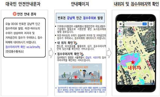
Citizens will receive flood risk information via safety alert messages (CBS). By clicking on a link included in the message, they can check whether their current location is in a flood-prone area and view the overall status of risk areas.
The government plans to establish a standard model for urban flood forecasting based on the results of this summer's pilot operation and create a nationwide expansion roadmap by the end of the year. This initiative aims to build a flood response system that citizens can truly feel.
Song Ho-seok, director of water resource policy at the ministry, stated, "We will strengthen the dissemination of detailed information and enhance organic cooperation among relevant agencies to thoroughly protect the lives and property of our citizens from the heavy rains this summer."
* This article has been translated by AI.
Copyright ⓒ Aju Press All rights reserved.