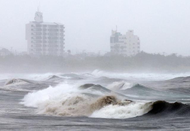
Typhoon No. 6 made landfall in southern Wakayama Prefecture on June 3, prompting Japan's new disaster weather information system to issue its first-ever highest-level alert. A special flood alert at level 5 was issued for the Koza River in Wakayama, while flood risk alerts at level 4 followed for the Meguro and Kanda rivers in central Tokyo. The typhoon has intensified the rainfront, causing heavy rainfall risks to spread from western Japan to the greater Tokyo area.
According to the Japan Meteorological Agency, Typhoon No. 6 made landfall in southern Wakayama around 4:30 a.m. on June 3. As of 8 a.m., it was moving northeast at 40 km/h, approximately 40 km southeast of Shima City in Mie Prefecture. The central pressure was recorded at 980 hPa, with maximum sustained winds of 25 m/s and gusts reaching 35 m/s. The typhoon had already caused casualties due to strong winds and heavy rain in Kyushu and Okinawa, where two men working on power line repairs were electrocuted; one man in his 30s fell unconscious, while another in his 40s suffered burns on his left hand.
The highest alert was first issued for the Koza River in Wakayama at 5:35 a.m. Flooding was confirmed in the Tsukinose area of Kozagawa Town. This was the first time a level 5 alert had been issued since the new disaster weather information system began operating at the end of May. A level 5 alert indicates that a disaster has occurred or is imminent, requiring residents to take immediate safety measures.
Wakayama Prefecture reported that the highest evacuation order, termed 'Emergency Safety Secured,' was issued for some areas in Kushimoto and Kozagawa. This affected 755 households and 1,149 people in Kushimoto, and 862 households and 1,672 people in Kozagawa. The meteorological agency advised residents that it may be difficult to evacuate safely and urged them to move to upper floors of sturdy buildings or nearby elevated areas instead of going outside. The level 5 flood alert for the Koza River was downgraded to a level 2 flood warning by 8:50 a.m.
Flood alerts continued to be issued in the greater Tokyo area. The meteorological agency and Tokyo Metropolitan Government issued level 4 flood risk alerts for the Zenpukuji, No, Sen, Kanda, and Meguro rivers. Level 4 is the second-highest alert level, indicating that local governments may issue evacuation orders. The agency urged residents in river basins to prepare for flooding by moving to the second floor or higher of buildings.
Line rainbands also developed. The meteorological agency announced that line rainbands had formed in Tokushima and southern Wakayama, followed by the Izu region of Shizuoka and eastern Kanagawa. This phenomenon occurs when developed rain clouds continuously drop heavy rain in the same area, significantly increasing the risk of landslides and river flooding.
Transportation disruptions are widespread. JR East suspended operations on parts of the Shonan-Shinjuku Line, Tokaido Line, Sobu Line, Ome Line, and Chuo Line. Many limited express trains to Izu and Boso were also canceled. While the Tokaido Shinkansen continued operations from the first train, JR Tokai warned of potential long delays or emergency suspensions for morning trains.
Numerous flights have also been canceled. All Nippon Airways canceled 232 domestic flights and 55 international flights to and from Haneda, while Japan Airlines canceled 292 domestic flights and 37 international flights. Temporary school closures were announced in Chiyoda, Koto, and Shinagawa wards of Tokyo, with some schools in Saitama and Chiba also closing.
The Japanese government has begun its response. Sanae Takaichi, the Minister of Internal Affairs and Communications, instructed on June 3 via X (formerly Twitter) to assess damage, implement emergency disaster measures, and provide prompt and accurate information to the public. She urged citizens to take actions to protect their lives as early as possible. According to the Yomiuri Shimbun, the government elevated the information liaison office established at the Prime Minister's crisis management center to a higher status.
The prolonged heavy rainfall is attributed to the overlap of the typhoon and the rainfront. The Nihon Keizai Shimbun (Nikkei) explained that Typhoon No. 6 is pushing the rainfront northward over the southern sea of Japan, while southerly winds east of the typhoon are supplying moisture to the front, resulting in extended rainfall across various regions. The sea surface temperatures in the Pacific near Japan are also 1 to 2 degrees Celsius higher than average, contributing to the typhoon's sustained strength. It is also unusual for a typhoon to make landfall in June. According to the meteorological agency, this is the first June landfall since 2012 and the fourth earliest since records began in 1951.
The meteorological agency forecasts that the typhoon will continue to move along the Pacific coast of Tokai and Kanto during the day on June 3, with rain expected to persist over a wide area. By 6 a.m. on June 4, the expected rainfall in some areas could reach 200 mm in Kanto and Gokshin, and 120 mm in Tohoku. If additional line rainbands develop, localized rainfall may increase, so residents are urged to remain vigilant against landslides, flooding in low-lying areas, and river flooding, and to check the latest weather information and evacuation advisories from local authorities.
* This article has been translated by AI.
Copyright ⓒ Aju Press All rights reserved.